
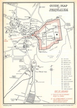
Guide Map of Jerusalem. PDR/MISC/1768.
Single sheet containing a lithographed map of Jerusalem for the use of British soldiers while the city was under British Mandate rule, printed in red and black, with a printed typescript to verso. 14 x 10 1/8 inches. Loose as issued. Small tear along central fold, discoloration along creases, light..... More

![Book ID: 53496 SWPA Newsmap Jan. - July 1944, Vol. 1 [Southwest Pacific Newsmaps]....](https://bernettrarebooks.cdn.bibliopolis.com/pictures/53496_015.jpg?width=320&height=427&fit=bounds&auto=webp&v=1781555944)